The Snowdonia Skyline Route – 24 tops in 24 hours.
Walk west then south-west out of Conwy, keep Anglesey to your right, the rest of Wales to your left and keep climbing those lovely ridges until you get to the other end of the National Park. Simple as that? In principle, yes. And it is one of the most rewarding 24 hours available to the British walker.
I wanted to start at 6pm but ended up starting over half an hour earlier; the teashop shut. So, full of a pretty wonderful chocolate cake, eaten looking at the town square at Conwy, I blundered westwards, through a couple of missed turns before I found the route onto the open hill. Strange indeed this; Conwy town has a direct path out onto some of the most scenic territory anywhere and the route is positively hidden. Now it had just gone 5.40 and in front of me lay one of the great concentrations of spectacular mountain ridges.
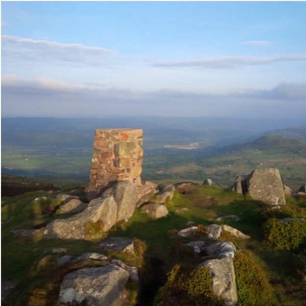
Conwy Mountain may only be 824’, but it feels like a mountain alright; views down and out to the shimmering Lafan Sands and Anglesey floating above the sea, all in soft evening sunlight. And the next 5 miles or so contains no summits, just a gradual gain of height up to Tal y Fan, the first 2000’er. But the scenery is magnificent. To Sychnant there are dozens of paths; from Sychnant I kept the sun and seaward view by staying west of the watershed above the Fairy Glen, then crossed the spine of the hill south of Maen Esgob, to follow a track to the Standing Stone and nearby quarry. Actually it all reminded me of the first miles of the Lyke Wake Walk; widening views all round to town and country as the sun set. Tal y Fan is a curious summit, a rocky spine running east-west above the heathery moor. After that there is a heathery trundle over Foel Lwyd followed by a disconcertingly deep bwlch – the first of many – and the long pull to Carnedd Y Ddelw and then Drum. Anglesey had also now landed again; very quiet. The ascent of Foel Fras is a really dull long grass slope; so mindless that I counted to 600 plantings of the left foot. You know you are close to the top when you encounter the designers’ only acknowledgement of Foel Fras as a 3000’er, a rash of boulders. The next miles are the easiest on the whole trip, grassy uplands leading to Carnedd Gwenllian and then on to the stone shelter on Foel Grach. By now, I had moonlight, which was reflecting brightly off Yr Elen, a tempting top, but not on the skyline.
Now, this was where I had a cunning plan – as I had done years ago, doing the Imperial 3’s – to spend 3 hours resting my legs in a bivibag at the stone shelter at Foel Grach. I spent the 3 darkest hours there – 11 to 2am – and was happy to move on as the cold seeped into me. Ahead lay the easy ascent to Carnedd Llewelyn, far left for the summit, then the long tramp to Carnedd Dafydd. From here I needed light and I got it as, slowly, dawn organised itself from somewhere North of Merseyside. I remembered to watch for the steepening ground from Pen Yr Ole Wen, into that gully above Afon Lloer and remembered also to replenish my water supplies. But I had forgotten how slippery the next bit – all wet and dewy grass – could be. I even saw another torch, briefly, but was soon concentrating on trying to use my feet – poor roadholding – rather than my backside – bumpy ride - to progress. By the time I reached the track I was thoroughly relieved to be still sprain free, albeit the possessor of two very wet feet. This was a very low bwlch, but, in front of me, emerging into daylight beyond the A5, was the one and only Tryfan.
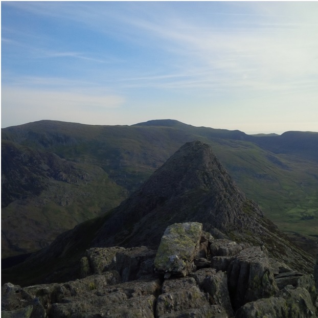
And this where this route starts to come into its own; it was 5 am and, after 18 miles and 6000 feet of ascent I was no longer fresh. But what was in front of me? One of the great cures for tiredness; Tryfan’s North ridge. 2000 feet of infinitely varied scrambling on sound rock, served up with a blazing sunrise; does mountain life get better then this? My watch told me I ascended in 90 minutes but it feels like 19 looking back. There to greet me were Adam and Eve; best piece of summit design anywhere. Then the swift descent to Bwlch Tryfan and Bristly Ridge. Of which I made a pig’s guts, straying left and emerging from there into Great Pinnacle Gap. The presence of discarded tape slings was disconcerting but, in the absence of skeletons and the like, I trusted in the pattern of Snowdonia scrambles; that if you wave your arms about long enough a jug hold will usually appear. Soon the Cantilever appeared and then – surely the designers put these two on the wrong plinths - a pile of discarded dinosaur torsos at the true summit of Glyder Fach.
Castell y Gwynt is another rock feature that looks to have been designed for a summit and then plonked somewhere temporary, so I climbed it. Glyder Fawr lay beyond, a less spectacular summit but a great view to the next challenge, Snowdon. From here, there is a mystery. Pen Y Pass is one of the great honeypot sites – and a horrid low bwlch - and Glyder Fawr one of the significant summits. And yet the connecting path, although marked by the odd red paint splash, is a bit scatty. Or was it me? At the bottom a path did coalesce, just in time to run into a fenced - off building site at Pen Y Pass.
And, who needs support when there is another café? I asked for an instant coffee and the guy gave me…instant coffee! Crashingly hot, so, starting to come under time pressure, I carried my paper cup up the PYG track and shoved it in a pocket once drained. It was just about cool enough to sip by Bwlch y Moch – maybe I exaggerate - and then it was time for another adrenalin rush; Crib Goch. This is another massive plus for this route; I had remembered the ridge as narrow but had forgotten the steepness and exposure of the ascent. And I still stumbled across a single lass heading optimistically up with 3 dogs. Bizarre. At the top I encountered a first bit of mist and a German-sounding guide talking nonsense - insisting that Horseshoe is a Welsh word? - and then running away, as if in a fell-race, from his client 100 metres at a time. Bizarre again. I let the client follow me for a while, but the ‘guide’ put paid to this by stopping to take a long telephone call. By the time this strange passage had elapsed we were nearing Crib Y Ddysgl and its false tops. Then the mist lifted and into view came Snowdon and its hordes. Blokes in Day-Glo, cameras, helicopters, winches…oh no…. but no sign of Kate Adie. It seems to have been an exercise; a practice for the Commonwealth torch event? At the summit café what I really wanted was liquid, quick. And the servery was busy with cashiers cashing, baristas baristing and patissiers just patissering around. But no-one to sell me some apple juice. Nergh! I wanted 10 minutes off my feet and got 7 or 8 minutes waiting and hardly a sit down at all. Never mind, I just set off down towards Yr Aran, then realised, pretty quickly, that I needed to take a right at the lights to hit the path that descends gently to Rhyd Ddu, the lowest point on my watershed.
Of all the start points for Snowdon, Rhyd Ddu is probably the nicest spot, so…. it was pretty quiet. Again, there are provisions available – see, you don’t need your long-suffering driver in a Transit – and in front lies Snowdonia’s best kept secret – the Nantlle ridges. Not high but fantastic landscapes. Then again, the first stretch is purgatory, the ascent of Y Garn; 1500 feet of grassy staircase. It didn’t help that I now met the single happiest school group I have ever seen, gambolling down the steep ground with shared noisy glee. By contrast I was by now the possessor of that crazed hollow stare of an addict reaching the end of the fix, the sort you see eyeing up the last pint of a bender or putting the last coins in a Vegas slot. Eventually the slope slackened but I had acquired company. Yes, I had a voice in my head, a female companion who was convinced that we would finish this together, even if we had to run the last bit down. As I later read, one of the local Welsh poets had written of this area ’There are voices and phantoms throughout the place’. Spooky? No, comforting, really. Y Garn is a fantastic viewpoint… but I cannot recall appreciating it on this occasion.
Soon enough the route became really interesting again with care required to negotiate the bouldery staircase up to Mynydd Drws Y Coed, with a view down one of the cleanest of vertical drops in the whole of Snowdonia. And from here on I met not a soul. No-one else was there to admire the ridge curving perfectly round the cwm to Trum Y Ddysgl, or the upland grass promenade – with that short rough gap – to the obelisk on Mynydd Tal Y Mignedd. The next bwlch is one of those disconcertingly low ones, but my female companion kept pointing out a path that struck out half right from the low point. Her judgment was perfect as I took it and it led me round the crags on the ridge, to the summit of Craig Cwm Silyn. More great views and, at last, no more major ascents. I could sense a nearing of journey’s end, complete with its metaphors for life itself; the going easier, everything more rounded and the sea nearer. Garnedd Goch was easy up but bumpy down and looked unexpectedly huge in retrospect. From a level bwlch I picked up the thinnest path to Mynydd Craig Goch. From here it was all down and I had 40 minutes left of my 24 hours. Much of which I wasted by straying too far right / down. ‘She’ - the voice in my head - was right, I reflected, as I hobble-ran down the hill on a path that led unerringly, drat, to a new fence. Down towards Llyn Cwm Dulyn I lurched, to a stile, which led in turn to one of those mysteries of the countryside, a 1 in 5 grass slope that somehow holds ankle deep water. So, when I reached my target, the National Park boundary, the only sound I could hear - splurch, splurch – was that of water sloshing around in my runners. The time was 5.36pm. I had been going for nearly 24 hours and can have rarely felt worse; then again, I had just found a fantastic route and have rarely felt better.
So, there is the challenge; keep the sea to your right, Wales to your left and climb the skyline in front of you. PS, you might want to wait till the wind’s in the east. Then enjoy.
Some statistics:
- 23hrs 56 minutes taken to cover 39 miles, N P Boundary to N P Boundary;
- 24 tops - including c16,000’ of ascent and descent;
- nil – number of people encountered (that I recall) Sychnant to Ogwen and Mynydd Drws Y Coed to Nebo;
- 4 Grade 1 Scrambles: Tryfan North ridge, Bristly Ridge, Crib Goch ascent, Crib Goch traverse
- 3 other scrambles: Tryfan South ridge; Crib Y Ddysgl, Mynydd Drws Y Coed
- 4 food and drink supplies (not 24 hrs): Pen Y Pass, Yr Wyddfa, Rhyd Ddu, Ogwen Cottage (W end, Llyn Ogwen)
Getting there
- buses Nebo to Bangor, 2 hourly service, Mon-Sat, a really nice run
- trains Bangor to Conwy, hourly service or better, Mon-Sat, but Conwy is nominally a request stop (but loads of people get off)
10 reasons why Snowdonia Skyline is a better trip, even, than the mighty Welsh 3’s
1. The route has a single theme, the skyline, rather than statistical distinctions such as 3000’, 1000m.
2. The best views in Snowdonia are looking west, and they are in front of you throughout.
3. The route includes several outstanding scrambles and all bar one are used the best way, in ascent.
4. The route has a continuity of line and there are no ‘out and back’ elements – such as to Yr Elen.
5. The route is navigationally obvious, with no temptingly daft options.
6. Each of the major lengths of descent are on gradual slopes or civilised paths.
7. The route includes 2 areas, the northern Carneddau and Nantlle, which deserve greater attention.
8. The start is at the start of the mountain skyline and the end….is at the other end of it
9. The start and end points are on the road network and readily connected by public transport.
10. There is comfortable accommodation near the start and end points.
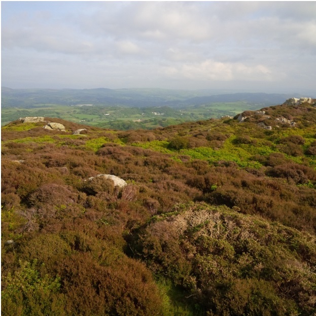 1.Snowdonia Skyline Route – first summit, the heathery top of Conwy Mountain
 2.As dusk gathers, a softer light at Tal y Fan summit, the first 2000’er
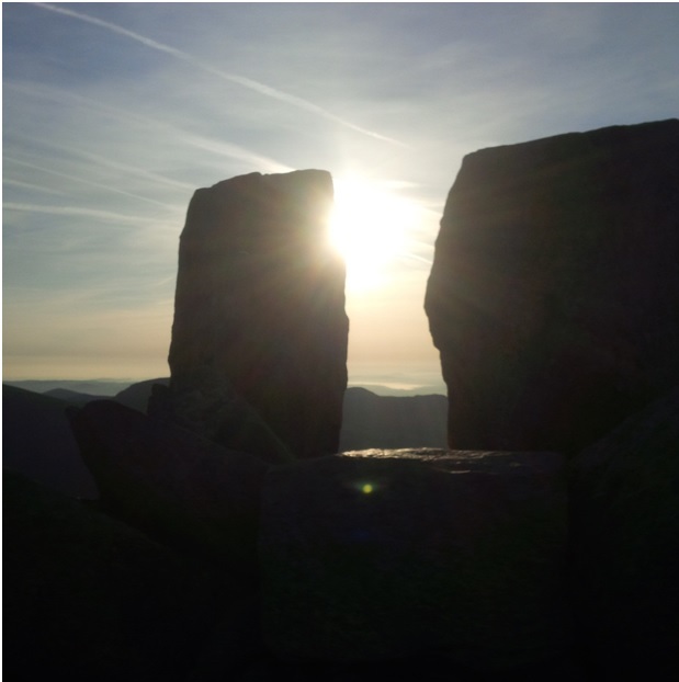 3.Does mountain life get any better than a sunrise at a summit. Adam and Eve, Tryfan summit
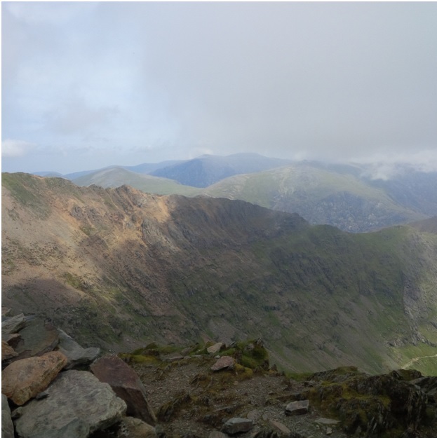
 4.From Glyder Fach, the top of Bristly Ridge, Tryfan looks daftly insignificant
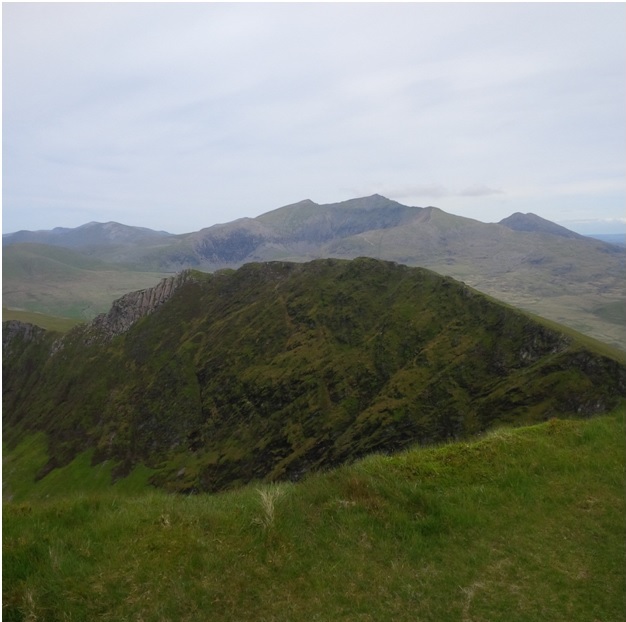
 5.From Glyder Fawr, a view of the continuing Skyline, over Snowdon, ahead, then the Nantlle tops beyond
 6.From Snowdon summit, looking back to the Glyderau and Carneddau
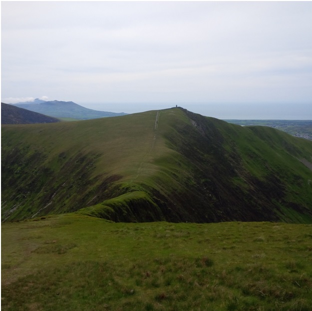
 7.The summit view, back to Snowdon from Trum Y Ddysgl
 8.The narrow neck of grass connecting Trum Y Ddysgl to Mynydd Tal Y Mignedd
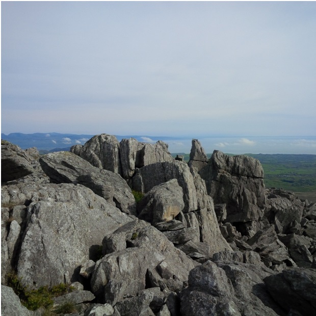 9.Hazy sunshine, light winds, still, at my last summit, Mynydd Craig Goch
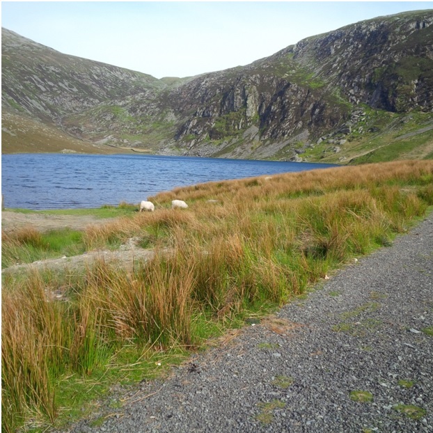 10.A look back to the high country, from the shore of the blue Llyn Cwm Dulyn.
Written and photographed by Chris Wearne. As seen in Spring Edition of The Great Outdoors Magazine.